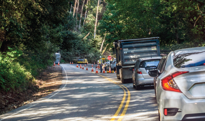
There’s traffic ahead. Brake lights illuminate. Vehicle speeds wind down from a cruising 55 to a sluggish 30 mph. In instances like this, commuters can simply tap the maps on their Apple CarPlay or Android Auto devices and look for an alternate route.
Commercial and vocational drivers of Class 5-8 don’t always have that luxury. Routes that haven’t been approved by their dispatch team could contain bridges with weight restrictions or pass through a residential area where large trucks aren’t allowed or can’t adequately maneuver. When a commercial driver finds themselves in this situation, is their only option to sit in traffic wasting valuable time?
The solution to the problem lies in maps built specifically for commercial vehicles. Dwayne Lazarre of Trimble MAPS, map intelligence for commercial fleets, says that Trimble MAPS strives to be the Google Maps equivalent for commercial drivers. And the company is well on its way to becoming just that and even more.
HOW IT WORKS
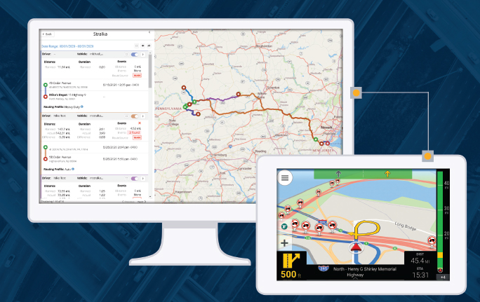
Achieving the Google Maps equivalent for truckers is simple. Trimble MAPS typically integrates into an existing ELD provider’s platform. Trimble MAPS works through a third-party application or through an integrated, embedded application within the logging device itself. For fleets that don’t use ELDs, Trimble MAPS is also available on smartphones and tablets through an iOS or Android app that can be downloaded from the app store. Large fleets that would like to implement Trimble MAPS on all their vehicles can also contact Trimble MAPS directly for an easier, less tedious way to install Trimble MAPS on hundreds of vehicles. Once drivers have access to the platform in their cab and managers and dispatch have access in the back office, the two can work together to find the best route.
WORKING TOGETHER
Fleet managers and dispatch personnel can spend hours planning the perfect route. Yet once drivers see the route, they might think differently. Seasoned drivers know whether there’s a school on the route causing traffic during the morning and afternoon or whether a recent storm caused a stream to swell out onto the road. To combat this, Trimble MAPS offers the same functionality in the cab as managers see in the back office. This allows drivers and fleet managers using Trimble MAPS to plan routes together—and this is especially helpful when planning for the last mile.
THE LAST MILE
From what Lazarre has seen, when drivers get in trouble, it’s typically during the last mile—and that isn’t exclusive to the parcel delivery segment. Last mile includes delivering wet cement to a construction site, delivering tools to a jobsite, or picking up and dropping off at a facility. Trimble MAPS is a great solution for any fleet—large, small, consisting of Class 8, a pickup truck fleet, or even a mixed fleet.
Using Trimble MAPS, fleets have the opportunity to select the type of vehicles in their fleet, their height, weight, and restrictions. Fleets can also filter routes, such as avoiding highways or unpaved roads. Fleets can even create categories and subcategories to simplify their routes. For instance, a mixed fleet might have a subcategory of Class 8 over-the-road trucks and then another subcategory of box trucks, and another of pickup trucks and work vans. Trimble MAPS can then design a route specific to each of those categories based on the size and type of the load and the size and type of the vehicle.
A DRIVER’S TOOL
Despite having even the most high-tech data services fed to the back office, the driver often has the best insight to what’s happening on the road. The driver knows just how bad the storm is, they know how many lanes are open, and they know the reason for the slowdown. When a situation occurs that prevents the planned route from being the best option, Trimble MAPS gives drivers a view of alternate routes that are approved by the back office.
Going even further, last year Trimble MAPS developed a layer to the mapping data that gave drivers insight to the amenities that are around them. It allowed drivers to see if a certain truck stop had showers, where to find food, and more. This was especially helpful during the pandemic when Americans were stocking up on essential goods and drivers worked overtime to ensure stores were stocked. This year, Trimble MAPS layered traffic slowdown alerts to its mapping data. This is important for fleets carrying heavy loads because if they can anticipate the slowdown, they can begin slowing their rig in advance.
LOOKING AHEAD
Trimble MAPS is working even harder to eventually be able to send updates to the driver for the exact time they might wait at a facility to unload or load their truck or suggest taking a break because there’s a storm coming that the driver can avoid.
All in all, Trimble MAPS gives drivers “tools that allow them to organize their day and make the best decision based off a changing environment,” Lazarre says. And any tool that benefits a driver and their time benefits the company at the bottom line.
FOR MORE INFORMATION
Find out more about Trimble MAPS, visit www.maps.trimble.com.